28 April . 2020
Sweetwater’s newest trail follows historic stagecoach route
When you walk along Sweetwater’s newest trail, Llano Stagecoach Trail, you’re retracing part of a historic stagecoach route that ran between Austin and Llano in the 1800s.
Before railroads came to this part of Texas in the late 19th century, stagecoaches were the most important method of moving people, freight and mail. Look closely, and you can see the two parallel gravel tracks of the old stagecoach route along part of Llano Stagecoach Trail, which extends for approximately one mile. Other remnants of the stagecoach route were found in other parts of Sweetwater as well.
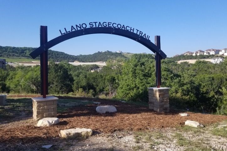
The history of the stagecoach route is noted in the trailhead’s distinctive arched marker in the Hidden Springs neighborhood. Hidden Springs is located along Pedernales Summit Parkway, near the main (east) entrance along Highway 71.
Along with recognizing history, Llano Stagecoach Trail provides an important connective link in Sweetwater’s overall trail system, which will extend for approximately 10 miles once completed.
This new trail connects Hidden Springs and future neighborhoods in the southeast quadrant of Sweetwater to Sunset Trail, which leads to the 10-acre Sweetwater Club community center.
Trails are part of more than 700 acres of recreational amenities and natural open space preserved in Sweetwater’s 1,400-acre master plan.
Here are brief descriptions of Sweetwater’s other trails, which meander through some of the community’s most scenic and dramatic Hill Country terrain.
Sunset Trail – Rated as Difficult, Sunset Trail is a .4-mile trail that treats residents to diverse scenery, including three waterfalls and a wildflower meadow.
Canyon Trail – Also rated Difficult, Canyon Trail is a 1.2-mile trail that leads to rugged scenery amid steep slopes and low water crossings.
Limestone Falls Trail – Rated Moderate, Limestone Falls Trail is a 1.2-mile trail that leads to one of Sweetwater’s most scenic secrets, a natural waterfall and pond with a limestone bottom and crystal-clear water. The Picnic Rock is a popular spot to rest and enjoy a snack.
Greenbelt Trail – Rated Low for difficulty, Greenbelt Trail is a popular .54-mile trail is easily accessible for all Sweetwater residents. A neighborhood park with a playground lies between the two trailheads.
Maidenhair Trail – Maidenhair Trail is a one-mile trail leading to a scenic waterfall and grotto, an 800-year-old Texas Madrone tree, a wildflower meadow, and an old windmill and water tank from the land’s ranch heritage. Rated Moderate, this trail offers one of the community’s highest lookout points.
Which Sweetwater trail would you be likely to enjoy most? Take our fun quiz to find out.